Purpose of chapter: to introduce MapSet, that handles option settings that control behaviour and display of all maps (current and history) in the Map page.
Local TOC
Overview
A tap on the Screwdriver icon in the navigation bar of the Map page opens the MapSet page:
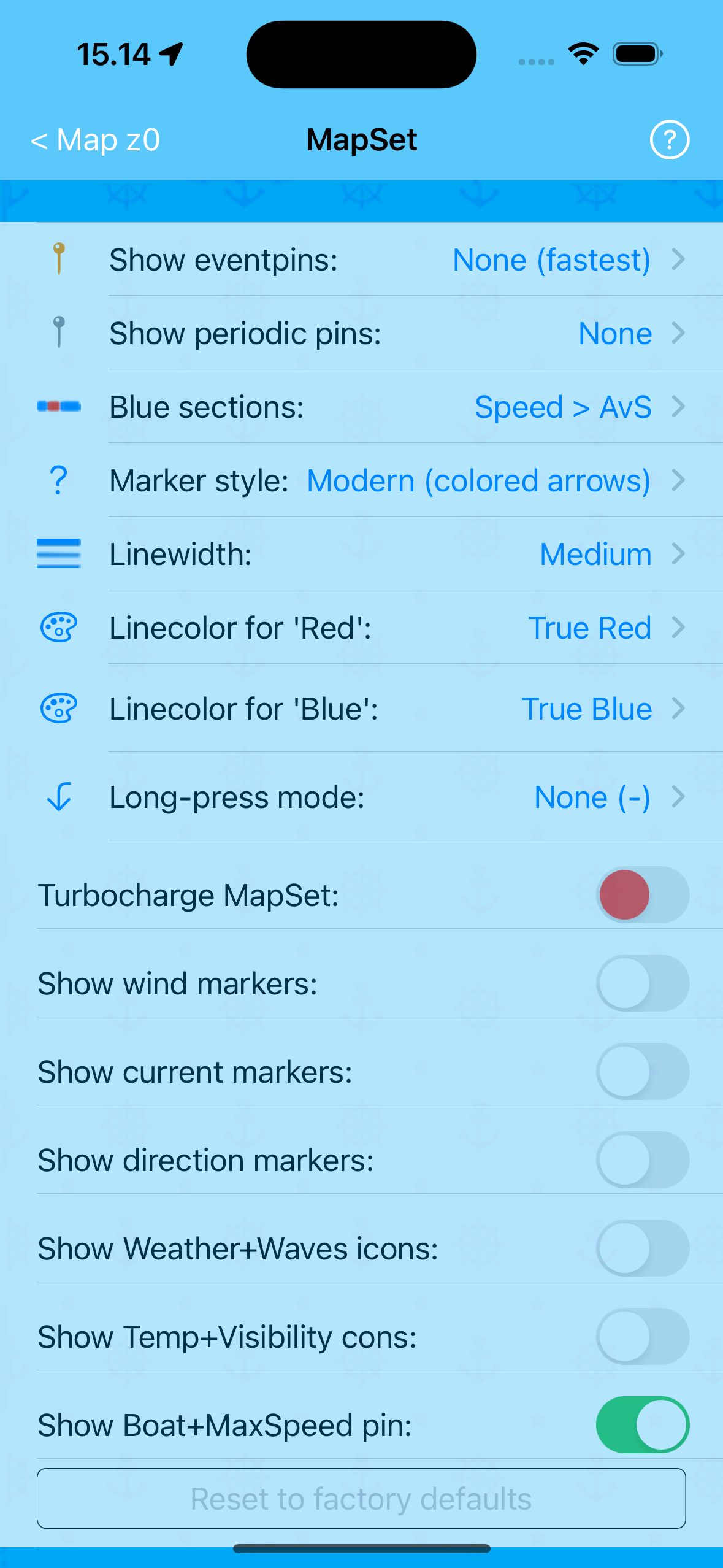
Screenshot from an artificially extended iPhone
Tapping any of its Help spots:
- the button in the navigation bar of the:
- MapSet page (shown above)
- (sub)pages opened by the Pickers (e.g. Show eventpins:)
- labels of the switches (e.g. Show wind markers:)
- opens the MapSet Help pages.
The Reset settings to factory defaults button is disabled (dimmed) because the settings shown above are the factory settings.
This page has no Options menu.
Showing Periodic pins, example
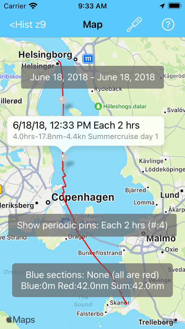
As seen in the example below, Periodic pins are shown with grey pins:
Showing markers and icons, illustrated
Showing wind- and currentmarkers
Showing wind- and currentmarkers in modern style
Imagine the simulator sailing along equator heading west.
With regular intervals, registration of wind conditions are done. The wind-direction is constantly from North, and the wind-force increases for each observation, going from 0 Beaufort (Calm) all the way up to 12 Beaufort (Hurricane).
With larger intervals, also registration of current conditions are done. The current-direction is constantly from Port side, and the current-force increases for each observation, going from nil all the way up to >5knots | >2.5m/s. This is shown like:
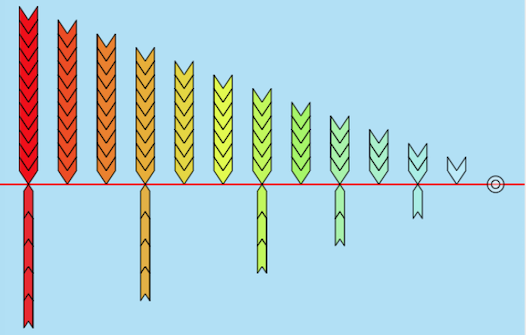
The color scheme follows this convention.
Showing wind- and currentmarkers in classic style
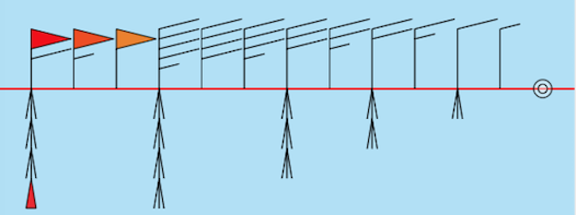
Same track as above, but in classic style:
Showing icons
Showing weather & waves icons
On the equator trip registrations of weather & waves conditions are also done.
The weather conditions are show below as icons on starboard side leftwards according to this list:
- Cloudless
- Some clouds
- Cloudy
- Overcast
- Hazy
- Foggy
- Grey sky
- Drizzle
- Rain
- Strong rain
- Sleet
- Snow
- Thunder

Eventpins are shown here. Icons North of these pins are moved a bit away for readability.
The wawes conditions are show above as icons on port side leftwards according to this list:
- 0. Flat
- 1. Ripples
- 2. Small wavelets
- 3. Large wavelets
- 4. Small breaking w
- 5. Mod long waves
- 6. Long waves
- 7. Sea heaps up
- 8. Mod high waves
- 9. High waves
- 10. Very high waves
- 11. Xtrm high waves
- 12. Huge waves
Showing temp & visibility icons
Finally, on the equator trip registrations of temperature & visibilities conditions are done.
The temperature conditions are show below as icons on starboard side leftwards according to this list:
- Very hot | >30°c | >86°f
- Hot | 25-30°c | 77-86°f
- Warm | 20-25°c|68-77°f
- Mild | 15-20°c | 59-68°f
- Tmp | 10-15°c | 50-59°f
- Cool | 5-10°c | 41-50°f
- Cold | 0-5°c | 32-41°f
- Frost | <0°c | <32°f

The small, black icondots indicate which locations the icons relate to.
The visibility conditions are show as above icons on port side leftwards according to this list:
- Good
- Mod
- Misty
- Lgt fog
- Hvy fog
Showing all icons
If both the Show weather & waves icons and the Show temp & visibility icons switch is set ON, the equator trip displays like:
When two icons must be shown at the same side, then weather & waves icons are placed inside temp & visibility icons.
Showing markers and icons
When all four switches are set ON, the map display could become quite crowded:
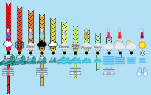
There is no icondot for the rightmost icons - to not hide the 'no wind' and the 'no current' markers (hollow circles).
In many cases it will be best not to activate all switches simultaneously, but instead switch back and forth between Map settings and Map display.
Sailor Logbook App manual - © Copyright 2018 CoaSoft LLC Denmark